
Jarntimarra-1
Evaluating the Sites
Selecting the Regions
Conclusions
Jarntimarra-1
The Jarntimarra-1 expedition was undertaken to visit, evaluate and rank Australian Mars analogue sites for possible
use by the MSA for future field reseach activities such as testing the Marsupial
analogue rover and possible future deployment of an Australian analogue research station (MARS-Oz).
Australia is rich in locations geologists have identified as closely analogous Mars to environments observed on the
surface of Mars. Initial electronic discussion between MSA members identified many of these, with further research
identifying further sites of interest. Sites were nominated on the basis of scientific interest, the range of types of
environments in the vicinity suitable for testing equipment, and visual resemblance to Mars. The most attractive sites
were in central Australia, and most could be visited in a single 4WD trek.
Evaluating the sites
The Jarntimarra-1 expedition spent two weeks in the field and visited a wide range of sites. These are listed in
Table 1. The expedition route is shown in Figure 1. In undertaking this expedition, every effort was made
to obtain permission from the stakeholders, owners or custodians of the selected land before the visit took place,
though in all cases the visits were non-intrusive. A paper detailing the expedition and site selection process is in
press.
| Island Lagoon, Woomera, SA | Mt. Gason Bore, SA |
| The Breakways, Coober Pedy, SA | Mungeranie Bore, SA |
| Moon Plain, Coober Pedy, SA | Lake Eyre South, SA |
| The Painted Desert. SA | Milners Rock Pile, Birdsville Track, SA |
| Henbury Craters, NT | Coopers Creek, SA |
| Finke River Crossing, New Crown, NT | Mt. Gason Bore, SA |
| Mt. Hammesley Plain, SA | Mungeranie Bore, SA |
| Dalhousie Springs, SA | Sturts Stony Desert, SA |
| Lake Eyre South, SA | Clifton Hills dunes, SA |
| Milners Rock Pile, Birdsville Track, SA | Mt Gee, Arkaroola, SA |
| Coopers Creek, SA | Paralana Hot Spring, Arkaroola, SA |
| Mirra Mitta Bore. SA | Lake Frome Plain outwash fans, SA |
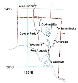
Figure 1 – Route of the Jarntimarra-1 expedition
At each site the survey crew filled in a database information sheet. This was a set of 13 prompts for each field in
the database: name, date, latitude/longitude, ownership, access, risks, maps, geology, climate, flora/fauna, history,
analogue value and references. These provided for factual entries in the Jarntimarra database. To record comparative
judgements with respect to the MSA's specific needs there was a separate assessment sheet with a list of 9
scientific and 8 engineering criteria, favouring sites that have intrinsic scientific value and offering a range of
conditions in which to test analogue vehicles, spacesuits and other equipment. There was also a set of 7 logistical
criteria relating to the distance from facilities and practical difficulty of operations and 8 visual criteria,
reflecting the public relations requirement for the site to photograph as if it were the Martian surface (Table
2).
| Scientific Criteria | Engineering Criteria | Logistic Criteria | Visual Criteria |
|---|---|---|---|
| Bedrock geology | Rocky | Security | Climate |
| Geomorphology | Boulders | Accessibility | Surface water |
| Surficial deposits | Sandy | Infrastructure | Colour |
| Groundwater | Dusty | Land tenure | Vegetation |
| Weathering | Firm | Liabilities | Physiography |
| Palaeontology | Chemical Activity | Safety | Landscape process |
| Microbiology | Wind | Outreach potential | Cultural association |
| Extremophiles | Temperature variation | – | Cultural disturbance |
Selecting the regions
A number of key issues for MSA were resolved during a three-day conference at Arkaroola village at the end of
Jarntimarra-1. The expedition found that most of the assessed sites fell within the boundaries of only six 200-km
diameter circles (Figure 2). The significance of these exploration zones is that each specifies a set of features
within easy reach of one simulated Mars mission, given a vehicle capable of extended traverses. If the centre of a
circle represents a habitat landing site, all the features within that zone would be accessible by sorties of no more
than 100km. Each of these six centres represents a possible "landing site" for MARS-Oz.
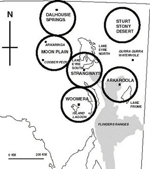
Figure 2 – The six prime regions selected during Jarntimarra-1
Based on the collective experience gained while filling in the site assessment sheets, each zone was rated on
5-point scale according to the above specific characteristics. Engineering and science scores then were doubled to
reflect their importance relative to the other criteria in the total score. On this basis, the Moon Plain, Woomera and
Arkaroola zones achieved equal ranking.
To support the goal of recommending a premier site for the 2002-2003 season, the tie was broken by considering the
arguments of individual expedition members advocating each zone. Eventually the case for the Arkaroola region prevailed
by virtue of its unique combination of logistical convenience (hospitable base at nearby Arkaroola village; 8 hours road
travel from Adelaide; 1200m all-weather airstrip at Balcanoona), international scientific reputation and Mars-like
geology.
Specific Mars analogue research in the region has been three-fold, focusing on aeolian landforms, extremophiles, and
remote sensing. Studies of aeolian landforms compared Martian dunes at Nili Petra with terrestrial dunes at Gurra Gurra
Waterhole in the Strzelecki Desert. The extremophile work found radiation-resistant thermophiles in the Paralana hot
spring which is characterised by high levels of radon gas. The area has been used in remote sensing experiments
comparing hyperspectral imagery from the alteration halo surrounding the Mount Painter fossil hydrothermal system with
ground truth from a hand-held spectrometer. This last study is particularly relevant to detecting the presence of such
systems on Mars, which are believed to be good localities to search for microfossils. Potential Mars analogue geoscience
research in the area may include palaeontology, geomorphology and regolith studies. The Proterozoic sediments of the
area are known to host silicified microfossils and the sinters of the Mt. Gee fossil hydrothermal system show potential
for microfossil preservation. Geomorphological and regolith studies include evolution of the alluvial fans on the
eastern flank of the Flinders Ranges, nature of mound springs of Lake Frome, and landscape evolution of the northern
Flinders Ranges, where uplift has led to partial exhumation and dissection of ancient land surfaces buried beneath
Cretaceous cover.
Conclusions
The Jarntimarra-1 expedition examined a wide range of sites across South Australia and the Northern Territory. Many
sites were identified which had value as useful Mars analogues.
The preferred site for the proposed Australian analogue research station was on the gravel plains to the east of the
Arkaroola zone's central point, between the eastern side of the northern Flinders Ranges and Lake Frome. This was
chosen for a number of reasons. It will allow easy access to sites in the Flinders Ranges proper and on the plains that
surround Lake Frome. There are many different terrains and areas of extremely high scientific interest in the vicinity.
It will also simplify logistics, as a well-maintained, unsealed road runs up the eastern margin of the ranges, joining
the Strzelecki Track to the north and the Barrier Highway to the south. The exact co-ordinates of the Hab site will be
decided upon during a further expedition after discussion with relevant land holders.